The settlement, which is in a semi-arid area where temperatures can reach as high as 45°C, was set up in January this year to cope with the influx after another settlement, Um Rakuba reached its full capacity. The flat surrounding landscape, dotted with sparse bushes and rocky outcrops, is prone to flash floods that have become more severe in recent years.
Various studies, including by UN agencies, suggest this is due to changes in the climate that are resulting in increasingly unpredictable rainfall and rising temperatures across Sudan’s arid and semi-arid drylands. Climate change is being felt worldwide, but Sudan is among the countries that are most vulnerable and least ready to adapt to its effects, which it is experiencing while simultaneously struggling with conflict, poverty and high levels of displacement.
Last year, heavy rains and floods wreaked havoc across Sudan, affecting hundreds of thousands of people, including refugees and internally displaced people.
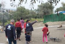
UNHCR, the UN Refugee Agency, and partners are already evacuating refugees whose shelters have been affected by the rains and putting other measures in place.
Akaran Napakiro, a field officer with UNHCR based in Gedaref State where the settlement is located, is leading these efforts.
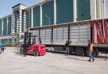
She explains that some 50 people whose tents were destroyed have been moved to one of the agency’s larger tents and that there are plans to provide refugees with more durable shelters to protect them from the elements. Relief items, including food, blankets and sleeping mats that were stockpiled will be distributed to affected families.
“We want to combine all these efforts to prevent other problems that come along with the floods, like cholera,” she says.
She adds that a topographical survey of the area was done to better understand which areas of the settlement are most at risk of flooding.
“The topographical images show that when it floods, the western side will be more affected,” Akaran explains. “We are creating canals to avert the water away from the population on that side.”
With access to the settlement set to become more difficult as heavy rains render roads impassable, there are plans to reinforce the road to the nearest town where supplies come from over 130 kilometres away.
SOURCE: UNHCR